What am amazing photo Celestine! The perspective of this is unique and makes one wonder where were you to get that shot!! Love how you made the photo full page and added creative interest with the subtle colors and graphic style overlays. Wonderful.
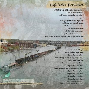
This was taken through the glass walls on the Davenport SkyBridge, more commonly known as the "Bridge to Nowhere" here in the Quad Cities. Well, I take it back, this one might have been taken on the platform just at the end of the bridge. This bridge was built as a tourist attraction to maximize Mississippi River views, and is really beautiful at sunset. This is the first time I have captured a photo of a train going through high water like that. The river floods very frequently here, and can be an amazing site. This flood in 2023 ranked #7 in the "highest crest" charts, but I've personally seen 7 of the top ten floods here.
If you can see the white wall along the buildings on the left, that is the temporary levee put up to save downtown buildings after the main levee on the river is breached. You can tell where the edge of the permanent levee is located by looking at the old-fashioned street lights near the railroad tracks. Behind that temporary levee are stacks of additional sandbags and pumps on diesel generators going 24-7. In the blocks behind the temporary levee the manhole covers are like geysers spewing up water from the overwhelmed stormwater system. It is hard to tell here, but a four lane road and LeClaire Park are completely underwater in front of the buildings.
If you can see the white wall along the buildings on the left, that is the temporary levee put up to save downtown buildings after the main levee on the river is breached. You can tell where the edge of the permanent levee is located by looking at the old-fashioned street lights near the railroad tracks. Behind that temporary levee are stacks of additional sandbags and pumps on diesel generators going 24-7. In the blocks behind the temporary levee the manhole covers are like geysers spewing up water from the overwhelmed stormwater system. It is hard to tell here, but a four lane road and LeClaire Park are completely underwater in front of the buildings.
I love this big photo, even if it is a terrible event. The perspective is beautiful.
I always find those floods overwhelming to see, and you know it also scares me a bit how more and more of these disasters are happening all over the world.
This site uses cookies to help personalise content, tailor your experience and to keep you logged in if you register.
By continuing to use this site, you are consenting to our use of cookies.